Material and Methods
A more detailed explanation on the origin and further processing of the used data
A more detailed explanation on the origin and further processing of the used data
The Düwelsteene were digitised as a 3D model in connection with the digitisation of the megalithic graves of Westphalia in the Megalithic Project of the Altertumskommission für Westfalen of the LWL using Image-based Modeling.
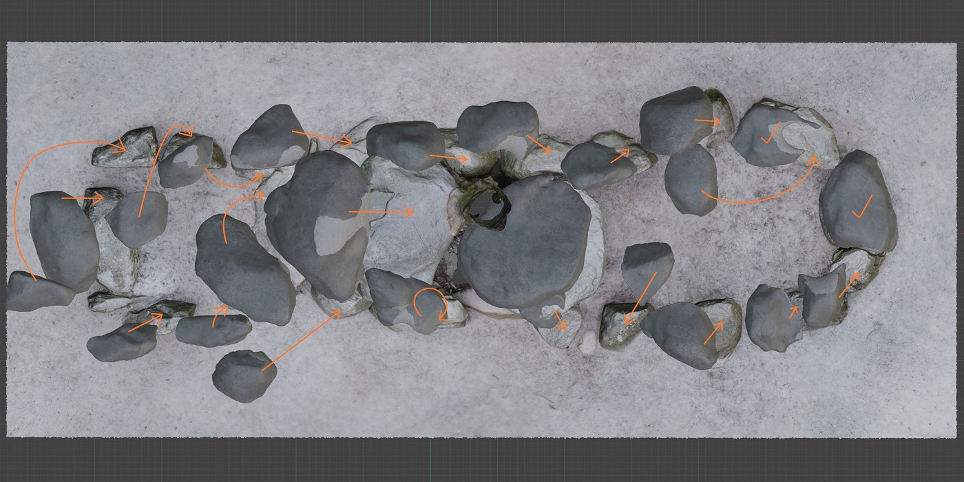
Image-based Modeling allows for the three-dimensional representation of objects
from many two-dimensional images. A historical precursor to this approach is
stereoscopy, which has enabled spatial viewing in 2D images since 1838. Here,
two slightly different images of an object from slightly offset perspectives are
used to simulate spatial perception.
Photogrammetry, especially 3D photogrammetry, builds on this stereoscopy.
However, it does not only use two images, but many, in order to create precise
three-dimensional models. By combining many images from different perspectives,
dense point clouds are generated, which allow for a detailed 3D model of an
object or landscape.
In archaeology, 3D photogrammetry has also found application. A popular term for
this process is "Structure from Motion" (SfM). This is an approach in computer
vision where the 3D structure of a scene and the camera positions are
reconstructed from a sequence of images taken from different viewpoints. The key
aspect of SfM is motion: the relative movement between camera positions is used
to extract depth information about the scene (Nyimbili et al. 2016).
In summary, one can say that Structure from Motion is a specific technique
within the broader field of Image-based Modeling. While SfM focuses on the
reconstruction of 3D structures from motion, IbM more generally deals with the
creation of 3D models from images, with SfM being one of many possible
approaches (Doneaus et al. 2011).
The 3D model of the Düwelsteene was created by taking photos of the megalithic
tomb from every possible direction and angle. These photographs were also
photogrammetrically rectified to correct any geometric distortion in the images
(Klinke 2018). A Nikon digital SLR camera was used to take the photos of the
Düwelsteene.
Since it is a large archaeological monument and the tomb was to be digitized in
high quality, not only were many images taken of the tomb itself, but every
single stone was captured from all possible positions. Thus, hundreds of images
were taken of the tomb and of each individual megalith, ensuring that the images
overlapped. This is necessary because from these overlapping parts of the
photographs taken side by side, the images can be merged and characteristic
structures can be recognized, leading to a pixel-precise structure.
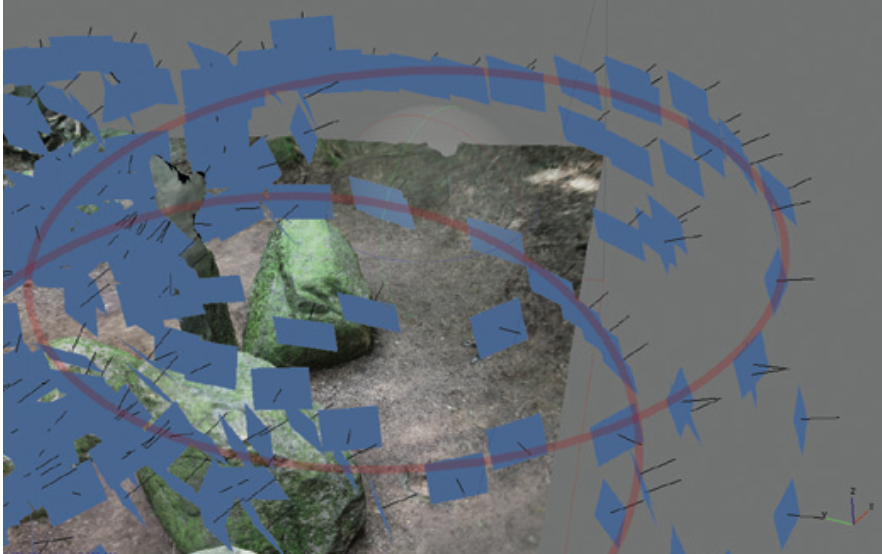
Structure from Motion as part of the digitisation of the Großen Sloopsteene (LWL-Altertumskommission für Westfalen/Klinke)
The photogrammetry software, in this case Agisoft Metashape, allows the
determination of capture positions and object structures by analyzing optical
shifts, such as edges, fracture surfaces, or crack lines, based on the compared,
inserted photographs. After processing, the initial calculation results are
visualized in the form of a rudimentary point cloud, technically referred to as
a "Sparse Cloud".
A further algorithmic step transforms this Sparse Cloud into a denser point
cloud, the "Dense Cloud". During this calculation, all individual images are
subjected to depth filtering to insert additional measurement points between the
existing ones of the Sparse Cloud. This is not based simply on interpolation,
but includes the consideration of relief changes between the measurement points
of the Sparse Cloud to ensure increased accuracy. The resulting Dense Clouds
reflect the current state of maximum surveying accuracy and are comparable to
the data results of terrestrial laser scanners. One advantage is that each
measurement point in the Dense Cloud already has a color value, unlike laser
scans, which require additional color information from supplementary
photographs.
In the subsequent process step, the photogrammetrically determined measurement
points are triangulated. In this procedure, three measurement points are always
connected, creating triangular surfaces. Usually, the spatially closest points
are used to ensure optimal accuracy. The resulting triangular surfaces can be
modified for further triangulations, primarily used to close gaps in the point
clouds. This triangulation procedure results in a so-called "Mesh" model with
the visual character of a three-dimensional wireframe model.
In a final computational step, a texture, similar to a covering skin, is applied
over the Mesh model. This gives the 3D model its photorealistic appearance. The
underlying texture comes from the photogrammetrically corrected individual
photographs from the initial processing step. In contrast to pure shape data,
which only represents the morphology and relief, this texture integrates
additional visual information such as color nuances, light reflections, and
shadow gradients that were captured during the documentation phase.
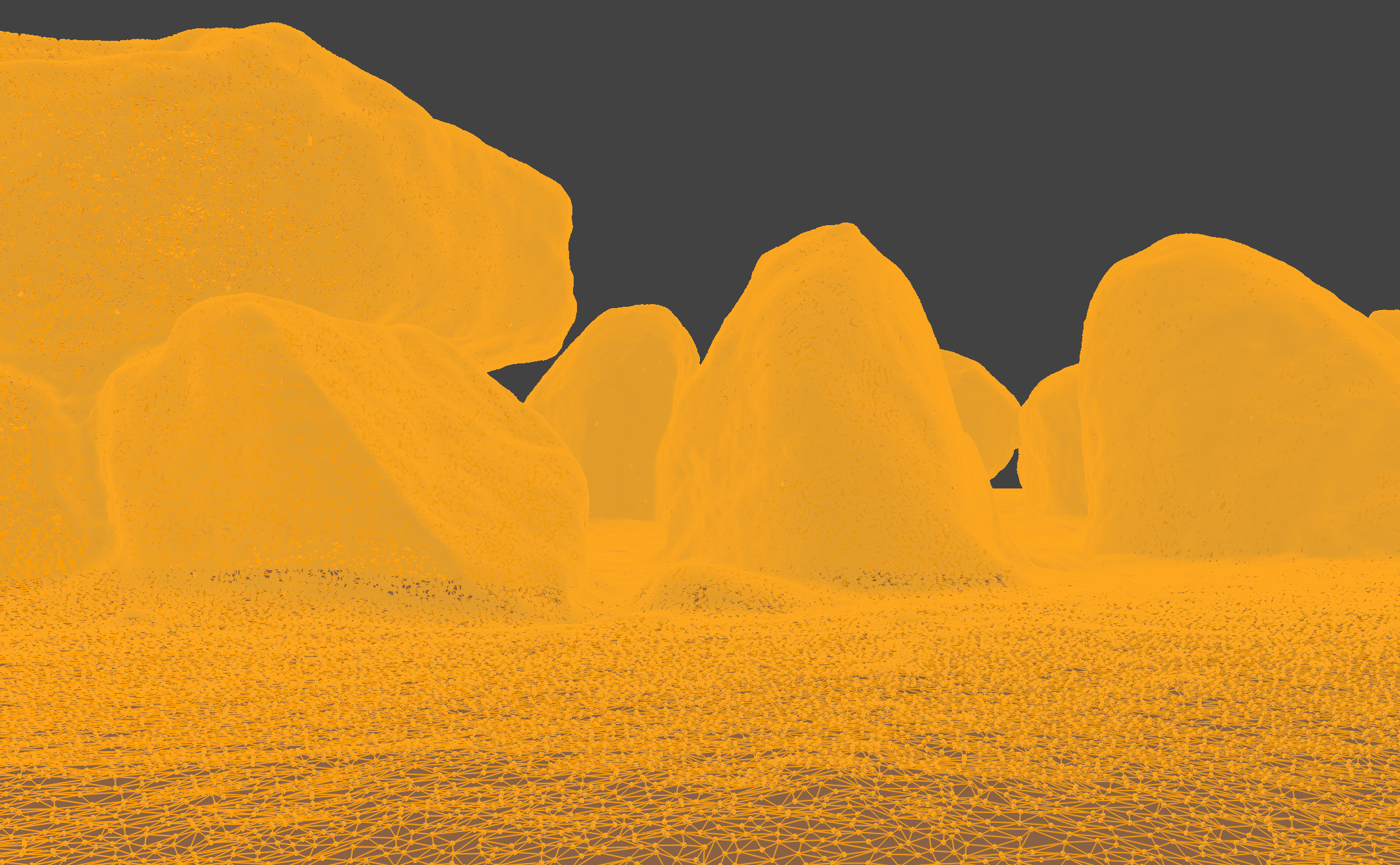
3D mesh of the Düwelsteene
The workflow for digitizing the megalithic tomb was applied by the
Altertumskommission für Westfalen for all previously digitized megalithic
tombs, such as the Großen Sloopsteene. Each unit (a single megalith or a
small group of megaliths located directly next to each other) is
photographed. These individual units are then entered separately into the
computer software Agisoft Metashape and converted into a rough 3D point
cloud. Once a unit has been digitized and transformed into a rough point
cloud, the next unit (the next adjacent megalith) is added to the software.
With each added megalith, the entire megalithic tomb is gradually converted
into a point cloud (Klinke 2021).
After the complete rough point cloud has been created, Metashape is used to
compute and create a dense point cloud, which is then converted into a 3D
mesh with an added photorealistic texture.
The point cloud of the Düwelsteene consists of over 378 million measurement
points. With this high-quality and high-resolution 3D model, the Düwelsteene
is digitized in a quality that can assist in monument conservation and
illustrate any movement or minimal destruction of the megalithic tomb in the
future, as it was precisely measured through image-based modeling.
In addition to descriptions and drawings in archaeological publications, similar megalithic graves in Westphalia and also in the Netherlands were used for the reconstruction of the Düwelsteene.
The Großen Sloopsteene, located in the Steinfurt district near Lotte-Wersen,
are one of the best-preserved megalithic tombs in Westphalia. Unlike the
Düwelsteene and other megalithic tombs in Westphalia, this large stone tomb
was not restored. Therefore, some of the megaliths are still in situ.
However, there were also human interventions at the Großen Sloopsteene, such
as a tomb opening in 1807. The Großen Sloopsteene, and the reconstruction of
this megalithic tomb (Klinke 2021), served as one of the examples for the
reconstruction of the Düwelsteene.
Another basis for the reconstruction of the Düwelsteene around 3000 B.C.
were the megalithic tombs of the Funnel Beaker Culture in the Dutch region
of Drenthe. These tombs were already mentioned by Johan Picardt in 1660 and
some have been restored since the 19th century. Many of these restorations
were carried out by Albert Egges van Giffen after thorough and
well-documented excavations. The documents of the excavations, as well as
photographs of the megalithic tombs in Drenthe before their restoration,
served as examples for the reconstruction of the Düwelsteene. Especially
since this tomb, similar to the megalithic tombs in the Drenthe region, was
also restored and thus altered at the beginning of the 20th century.
Information about the megalithic tombs in the Drenthe region can all be
found on the website hunebeddeninfo. There you can find information, 3D
models, photographs, and floor plans by Albert Egges van Giffen for each
individual tomb.
Together with staff from the Megalith Project of the Altertumskommission für Westfalen, each megalith of the Düwelsteene was classified by size, volume, and placement. The categories were capstone, orthostat (supporting stone), and wedge stone. Other categories would be perimeter stone and ground material from the inside of the tomb, but these building blocks of megalithic tombs were not found in the Düwelsteene or could not be identified with certainty. Each megalith was assigned a number through the digitization process, and the numbering followed the megalithic tomb in a clockwise direction. With these established numbers, each individual megalith could be individually selected and classified, based both on its own unique features and on how its placement influenced the overall structure of the megalithic tomb.
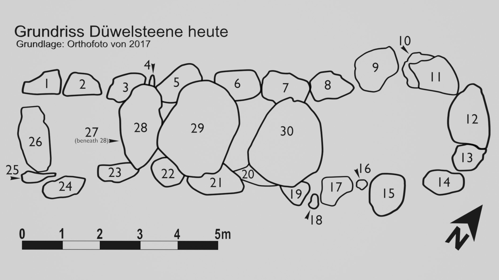
Numbering of the megaliths
To calculate the volume and subsequently the weight of the megaliths, the 3D modeling software Blender with the add-on 3D-Print Toolbox was used. Each stone was selected as a separate object and the volume was calculated in Blender using the add-on. After the volume calculation, the weight of each megalith was determined. The weight of granite depends on its density. The formula used to calculate the weight was the volume in cubic meters (m3) multiplied by 2700 kg, since granite weighs about 2.7 tons per cubic meter. Almost all of the megaliths of the Düwelsteene are only partially visible, and for this reason, only these partial 3D models could be used to calculate volume and weight.
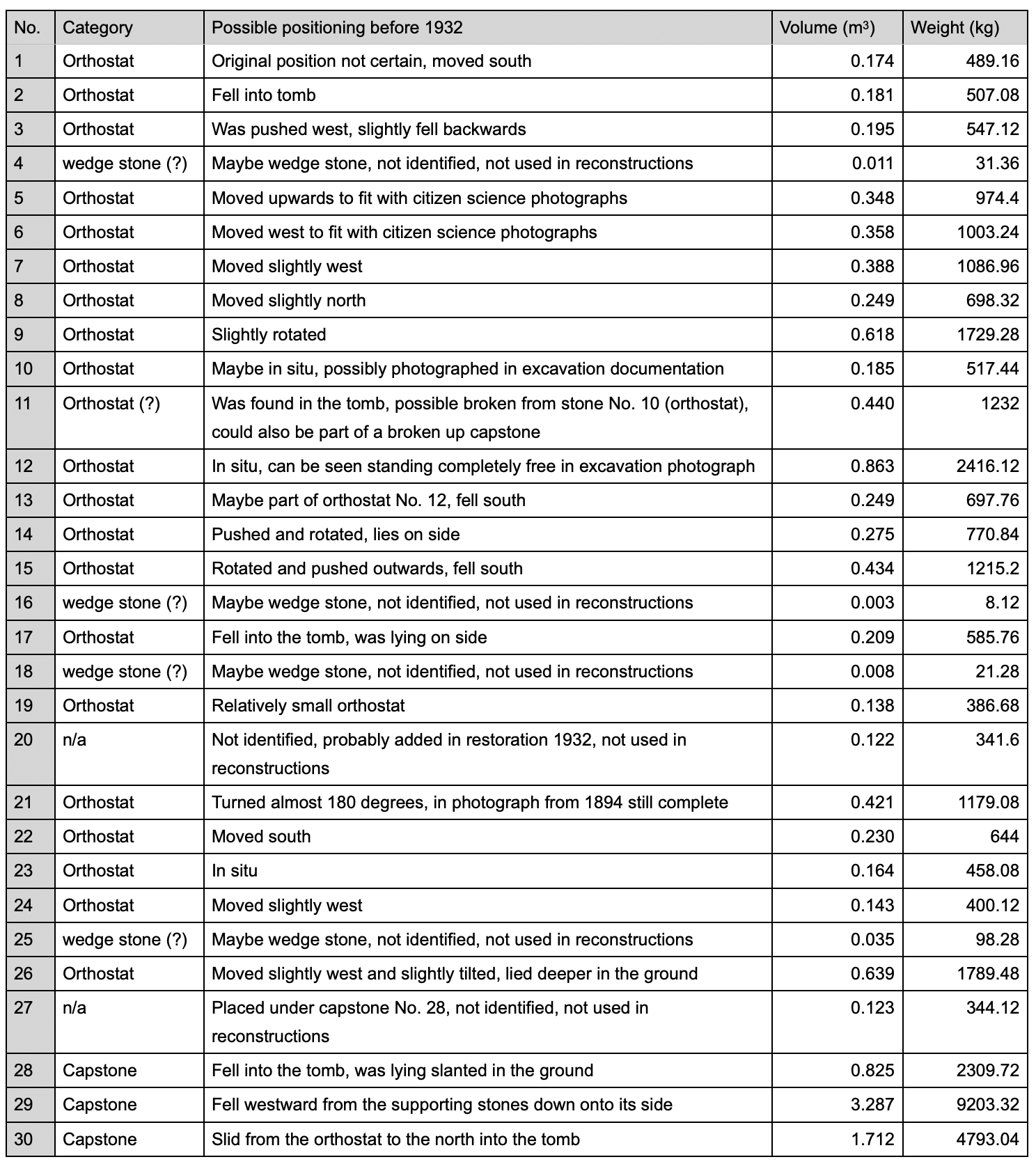
Classification of the Düwelsteen megaliths
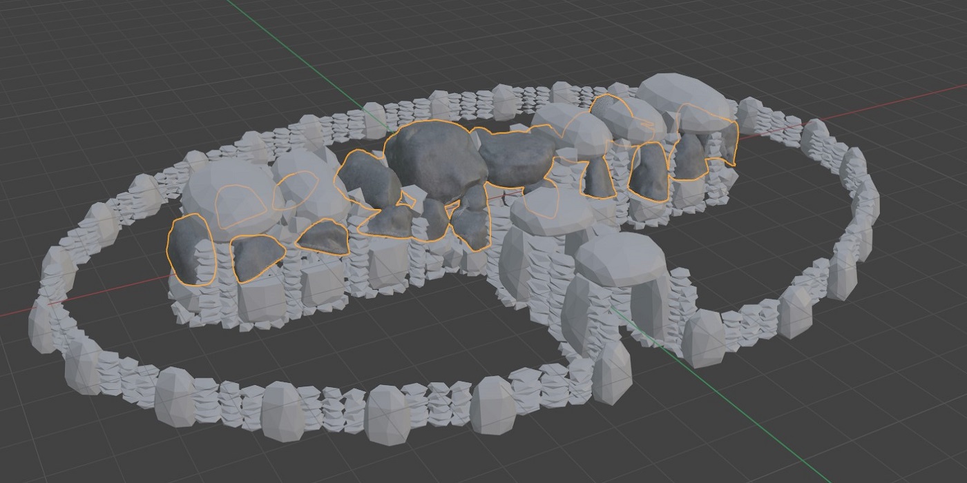
To create the digital reconstruction of the Düwelsteene around 3000 B.C., the previous reconstruction from before 1932 was used, as the arrangement of the megaliths provides a better template for how the megalithic tomb might have been built than the current tomb structure. Many of the megaliths seemed to still be in situ in photos from the Citizen-Science project and only needed to be erected or slightly rotated to form a reasonably uniform chamber wall. The orthostats of the Düwelsteene were moved and arranged to match the style of megalithic tombs found nearby or built similarly. A common structure of megalithic tombs belonging to the Funnel Beaker Culture, especially the western group, consists of two orthostats on opposite sides, with the flat part of the megalith facing each other. A capstone was laid on these two side stones, forming a yoke together (Bakker 2010). Similar to the Großen Sloopsteene, each of the support stones of the Düwelsteene was placed to form a uniform chamber of the tomb, without significantly changing the position or rotation of each megalith. This resulted in two parallel rows of orthostats, with two end stones at each end of the chamber in the southwest and northeast.
Abstract reconstructed megaliths
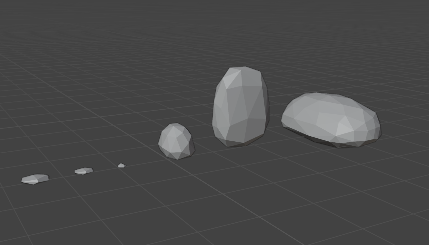
To create a reconstruction of how the Düwelsteene might have been built around 3000 B.C., missing stones had to be added. These stone replacements were intentionally designed in an abstract manner to make the different parts of the megalithic tomb reconstruction visible: a) the megaliths that still exist today and b) the stones that were added for the reconstruction. A basic orthostat was modeled in the 3D modeling software Blender, with a flat inner side, a convex outer side, and an overall oval shape of the substituted stone. From this basic shape of the orthostat, the capstone was similarly modeled, differing only in size. Other modeled replacement stones were the megaliths that formed the outer boundary, the wedge stones, and the stones that formed the gusset wall between the orthostats and the perimeter stones. The megaliths that formed the outer boundary were modeled after the orthostats but reduced in size. The other replacement stones were abstract versions of flat stones, which were then modeled to form a gusset wall. These various stone shapes form the basic structure of a passage tomb (Ickerodt 2020).
With all the building blocks for the reconstruction of the Düwelsteene around 3000 B.C. modeled, the first step was to place the capstones on the oriented orthostats. Since all three capstones that still exist today have slipped from their supporting stones, the most likely positioning had to be found. As these megaliths are only virtual models, it could be tested in which position and on which orthostats the capstones were most likely placed. Once all megaliths still visible today were positioned in the reconstruction, the modeled substituted stones were added. First, the missing lower parts of the orthostats were placed in the reconstruction, then the foundation of the orthostats, which consisted of smaller stone fragments used to fix the orthostats by wedging the smaller stone fragments underneath. A layer of flat stone fragments was laid to form the floor of the megalithic tomb. The gusset wall was added between the supporting side stones. Finally, the missing capstones were placed on the reconstructed tomb. The overall structure of the reconstructed Düwelsteene was based on the architecture of similar megalithic tombs like the Großen Sloopsteene (Klinke 2021) or the megalithic structures in the Netherlands.
In the reconstruction model, the outer boundary, consisting of smaller replacement megaliths, and the gusset walls were also added. The placement was problematic as there are no reference points for an outer stone boundary defining the structure of the mound above the tomb. Although there are no sources for a mound covering the Düwelsteene, it is likely that the tomb was covered similarly to the Großen Sloopsteene and the megalithic tomb of Rheine64, which was still found covered by a mound. With these comparisons in mind, the reconstruction of the Düwelsteene was modeled with a mound covering the tomb. With the decision to add a mound, the steepness and dimensions of the mound had to be defined. In the idealized plan of the Düwelsteene from 1932, stones are drawn that could indicate the outer megalithic boundary.
When modeling this boundary, it became clear that the radius shown by these drawn stones in the idealized plan was almost a circle and was too far from the long sides of the megalithic tomb. Most of the compared megalithic structures had at most two pairs of yokes forming the entrance to the tomb. With the radius of the outer boundary shown by the drawn plan, the entrance to the Düwelsteene would have been excessively long. Most megalithic structures of the western group in the Funnel Beaker Culture had an oval boundary that was somewhat flat on the longer parts of the tomb structure. The reconstruction model of the mound was reduced to resemble the compared megalithic tombs. The mound of the reconstructed model was created with the slip angle for sand in mind. The soil composition of the area where the Düwelsteene are found is significantly sandy, so the slip angle for the mound was defined as 30° degrees (Klinke 2021). With these definitions, a mound was modeled on the megalithic tomb, with the outer megaliths and the spandrel masonry acting as the boundary of the mound.
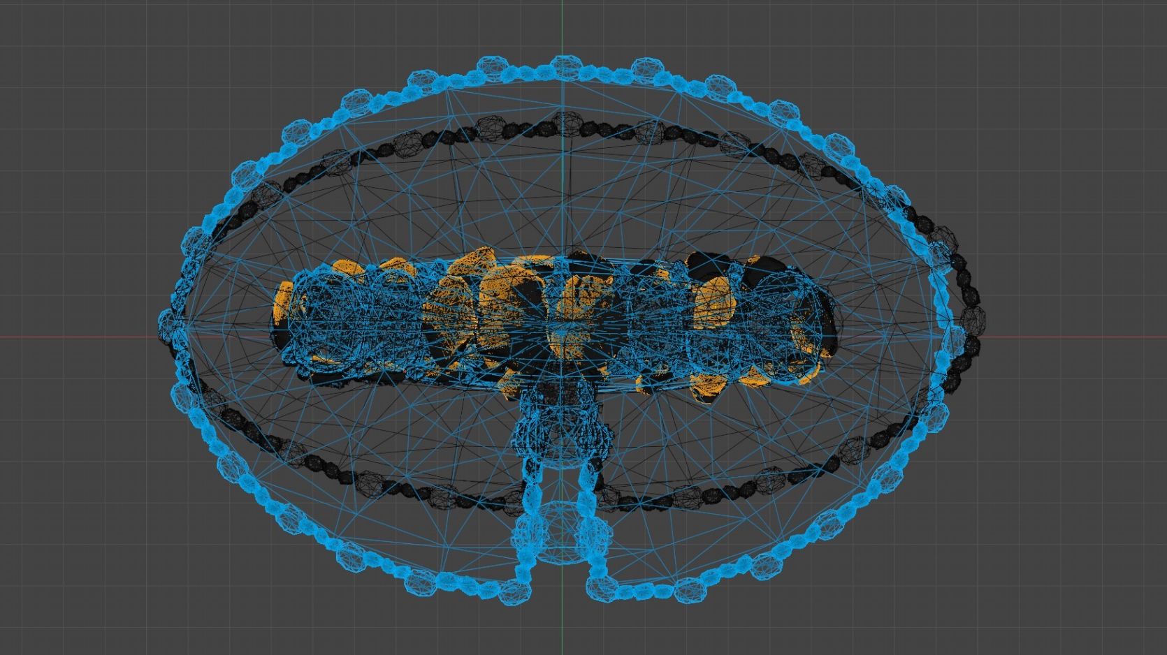
Boundary of the reconstructed burial chamber